In the 1950's, when not much was known about the effects of nuclear explosions, many nuclear tests were conducted at the Nevada Test Site north of Las Vegas. The tests were conducted both above and below ground; in the beginning with little or no safety precautions. When it became obvious that the underground nuclear tests in the Nevada Test Site were a serious safety risk for nearby Las Vegas, the Atomic Energy Commission ("AEC", today known as Department of Energy "DOE") decided to conduct the most powerful tests in even more remote areas.
One of a total of 10 such locations was the "Central Nevada Test Area", in Hot Creek Valley. It is located on public land, about 70 miles northwest of Rachel.
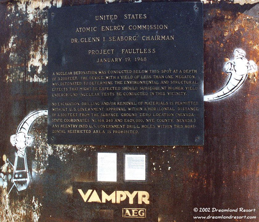
A series of underground thermonuclear tests was planned, more powerful than any of the tests before. Project Faultless was the first calibration test, intended to determine the geological impact. It had a yield of approximately 1.0 megatons, about 67 times the energy of the bomb that was dropped on Hiroshima, Japan! Other, even more powerful tests were to follow later.
Project Faultless was detonated 3,200 feet underground on January 19, 1968 at 10:15am.
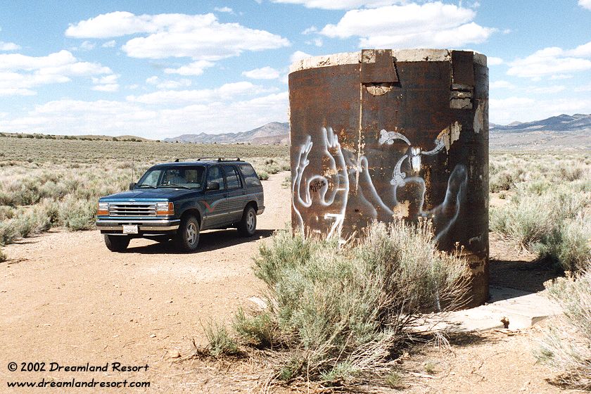
The results were devastating! The force of the explosion caused the ground in a radius of several miles to cave in and created several deep fault lines that despite some "restoration" efforts by the AEC are still visible today. A vertical shaft had been drilled into the ground to place the explosive device. Its walls were reinforced by a 7.4 ft. diameter steel pipe. The top end of the pipe was level with the surrounding terain before the test. After the explosion the top 9 feet of the pipe were exposed, due to the ground collapsing.
The blast also created a huge cylindrical underground cavity, a so-called nuclear rubble chimney. It is approximately 820 feet in diameter, and 2,460 feet in height. At its bottom lies over 500,000 metric tons of highly radioactive rubble, with radiation levels similar to the core of a nuclear reactor.
The completely unpredicted disastrous geological damage led to the cancellation of the entire project. The steel pipe was sealed with concrete and all other sites that were being prepared for more, even more powerful tests were abandoned. The excavations can still be seen nearby. A bronze plaque reminding of the test was affixed to the top of the steel pipe, which now serves as a memorial, marking Ground Zero of the Project Faultless test.
The center of the blast, deep inside the ground, is contaminated with radiation for thousands of years. But it appears that the surface is relatively "clean", and it is safe to visit the site. However, the plaque prohibits digging in the area, or even picking up material from the ground.
On the way, about 9.7 miles past the Warm Springs junction, you see a group of buildings and an airfield on the left side of US-6. This is Basecamp, built by the Atomic Energy Commission as base camp for the Central Nevada Test Area. After the project was cancelled the USAF took over Basecamp and extended the runway to its current size. Today it is used as an auxiliary airfield for the Air Force, including secret test flights out of TTR and Area 51.
6.6From Rachel turn left onto Hwy 375 north. Follow it for about 59 miles. At the Warm Springs junction turn right onto US-6 east. After 25.4 miles you see a small sign pointing left to "Moores Station". Turn left onto the well-maintained dirt road. At 6.6 miles from the highway fork left. At 12.1 miles you get to a 4-way intersection. Continue straight on the less developed dirt road, heading roughly west, for another 1.4 miles. Then you will see a mound of dirt directly ahead. The road splits here. Turn right, heading north. Then veer left, circling the north side of the mound. Another left turn onto a dirt track leading south brings you right to the monument shown below.
Suitable for most cars.
| Rachel | N 37° 38.801' | W115° 44.760' | ||
| Queen City Summit | N37° 45.129' | W115° 56.733' | ||
| Warm Springs | N38° 11.447' | W116° 22.218' | ||
| Basecamp | N38° 18.705' | W116° 16.807' | ||
| Moores Station Turnoff | N38° 28.792' | W116° 05.882' | ||
| Fork left | N38° 34.296' | W116° 7.205' | ||
| 4-way intersection | N38° 37.593' | W116° 11.402' | ||
| Project Faultless | N38° 38.058' | W116° 12.920' |
|
 |
 |
 |
 |
 |